


When I first studied How Drones Are Used on Construction Sites, I noticed one big shift: drones are no longer just flying cameras for impressive photos. They now help contractors document work, reduce risky inspections, track progress, measure materials, and improve communication between the field, office, and project owner. On modern building projects, drone data can turn a confusing jobsite into a clearer workspace.
What Are Construction Drones?
Construction drones are unmanned aerial vehicles fitted with cameras, GPS, mapping software, and sometimes sensors such as thermal cameras, LiDAR, or Real Time Kinematic positioning. A basic drone captures photos and videos. An advanced setup can create maps, 3D models, point clouds, elevation data, thermal images, and progress reports.
The value is in the data. Instead of depending only on scattered phone photos or slow manual walks, contractors can use aerial records to understand the full project faster.
Why Contractors Use Drones on Job Sites
Contractors deal with tight schedules, labor shortages, budget pressure, safety expectations, and clients who want better updates. Drones capture site information in minutes instead of hours, compare planned work with actual progress, spot delays early, and reduce confusion between teams.
They are useful on commercial sites, residential developments, roadwork, utility projects, earthmoving jobs, roofing work, and large properties where ground-level visibility is limited. They also create records that can support change orders, claims, inspections, and owner updates.
Main Ways Drones Are Used on Job Sites
Site Surveying and Mapping
Drones capture high-resolution images that software turns into orthomosaic maps, topographic data, contour maps, and 3D site models. This helps contractors study slopes, access points, drainage, boundaries, and existing conditions before major work begins.
For earthwork teams, drone mapping can support cut-and-fill planning, grade checks, and volume measurements. This reduces guesswork and helps compare field conditions with design plans.
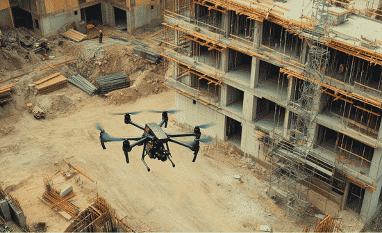
Progress Tracking and Documentation
Drone flights can be scheduled weekly, biweekly, or at key milestones. Each flight creates a visual timeline of the job. Project managers can compare current images with earlier flights to see whether sitework, concrete, framing, roofing, utilities, and exterior work are moving as planned.
This is useful for owners, lenders, architects, insurers, and subcontractors because everyone can see what is complete, delayed, or ready for review.
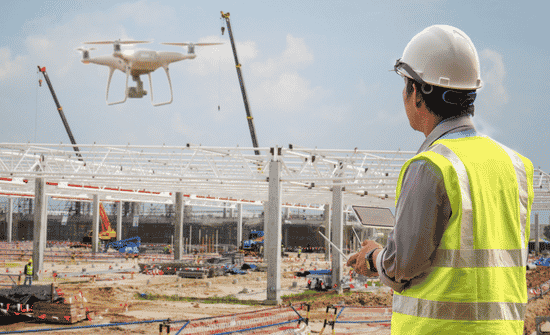
Safety Inspections
Drones help safety teams inspect difficult or dangerous areas. Instead of sending workers onto unstable roofs, scaffolding, steep slopes, towers, or hard-to-reach areas, teams can review those zones from the air.
A drone can also help check guardrails, trench conditions, traffic flow, access routes, housekeeping, material storage, and restricted zones. It does not replace a safety professional, but it gives that person a better view.
Roof, Facade, and Structural Checks
Drones are useful for roofs, facades, chimneys, exterior walls, bridges, towers, and elevated structures. They can capture close-up visuals without ladders, lifts, or scaffolding in some situations. This saves time during maintenance checks, deadly tornadoes construction reviews, punch list work, and exterior inspections.
With thermal imaging, drones can also help identify moisture issues, insulation gaps, heat loss, and possible electrical hot spots.
Stockpile, Equipment, and Material Tracking
Material piles are hard to measure accurately from the ground. Drone data can help calculate the volume of soil, sand, gravel, aggregate, and other stored materials. Better stockpile tracking can improve ordering, reduce waste, support billing, and prevent quantity disputes.
These insights become even more valuable as smart building materials used in modern construction require precise inventory management and accurate quantity tracking to keep projects on schedule and within budget.
Aerial views also show where equipment, deliveries, crews, laydown yards, temporary roads, and storage zones are located. This improves logistics when multiple trades share the same site.
What Drone Data Can Produce

A construction drone can produce aerial photos, videos, panoramic images, orthomosaic maps, elevation models, 3D models, point clouds, thermal images, and project reports. Some teams connect this data with CAD, BIM, scheduling tools, or project management platforms.
Rules and Planning Contractors Should Know
Commercial drone use requires trained operation, airspace awareness, registration where required, and compliance with aviation rules. Contractors should also consider privacy, nearby roads, neighboring properties, workers on site, weather, battery limits, insurance needs, and emergency procedures.
Before flying, decide who is responsible, what will be captured, where files will be stored, and who can access the data. A simple plan protects the contractor and the client.
Should Contractors Buy a Drone or Hire a Service?
Buying a drone can make sense for contractors who need frequent flights and have someone willing to get trained. Hiring a drone service may be better for companies that need mapping, thermal imaging, LiDAR, advanced reports, or occasional documentation.
The smartest first step is identifying the problem to solve. If the goal is progress photos, a basic service may work. If the goal is mapping accuracy of non-RTK ultra-lightweight and RTK-enabled survey grade drones or volume measurement, professional support is usually better.
Challenges of Using Drones
Drones are useful, but they are not perfect. Bad weather, strong winds, restricted airspace, battery limits, privacy concerns, insurance needs, and poor data management can reduce their value. If nobody reviews the data or uses it in meetings, the drone becomes another unused tool.
Frequently Asked Questions
1. Are drones useful for small contractors?
Yes. Small contractors can use drones for roof checks, progress photos, estimates, marketing visuals, site records, and client updates.
2. Can drones replace surveyors?
No. Drones can support mapping, but licensed surveyors are still needed for legal boundaries and certified surveys.
3. What is the biggest benefit of drones in construction?
The biggest benefit is faster visibility. Contractors can document work clearly and catch problems earlier.
4. Do drones improve construction safety?
Yes. Drones can reduce manual inspections in dangerous or hard-to-reach areas.
Final Takeaways
I see drones as useful construction technology because they solve everyday field problems. They help teams see the jobsite clearly, document progress, measure materials, inspect risky areas, and communicate with owners more confidently. When used with a clear purpose, a drone can save time, reduce risk, and make decisions easier.